Generic Automated Microbus Layout to Provide Area Coverage
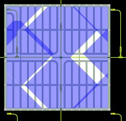
 The Automated Microbus system at the left, shown in yellow, serves an area of one square kilometer (5/8 mile on a side). The area is bounded by four arterials and contains four Microbus stations. One of these is an end-of-line station in the upper-left corner, and the other three have center platforms and are located along the lines running vertically. Four more stations outside the square are also shown; these lie in adjoining squares that are assumed to be identical to the first. They're included since their collection areas extend across the arterials into the original square. The image is drawn to scale.
All of the Microbus roadway is two way. It's entirely at grade except where it passes under the bounding arterials via structures similar to pedestrian underpasses. About 2 percent of the roadway consists of these underpasses.
Finding right of way for an at-grade system is not practical in many cases, and most applications are expected to be in new developments or where a special situation makes land available, such as an abandoned rail line. Initially, Microbus systems could cover a small area and provide internal circulation plus access to a rail transit system for longer trips.
The Microbus roadway breaks up the area it serves, but the six overpasses shown above allow pedestrians and bicyclists to cross. Three of the overpasses cross the Microbus line that runs horizontally. The leftmost of these allows persons in the lower part of the square to easily reach the center-platform station just above the "T" intersection, while the other two are not needed for station access, but instead provide general circulation. Each of the three remaining overpasses is part of a center-platform station. In addition to providing access to the platform from both sides of the station, they allow pedestrians to simply cross the Microbus roadway.
The local streets in the image are arranged in a grid and divide the area into blocks that are 780 ft by 240 ft (238 m by 73 m) measured street center to street center. This arrangement is only an example, and other street layouts are possible.
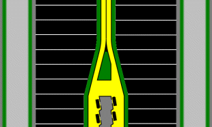
The two-way Microbus roadway is 15 feet (4.6 m) wide, and is assumed to be bordered by a 5-foot (1.5 m) buffer strip on each side shown below in green. This gives a total right-of-way requirement of 25 feet (7.6 m). The entire Microbus system, including the buffer strips, takes about 2.2 percent of the land. For comparison, if the local streets were narrow, with a total right-of-way of 50 feet (15 m), including planting strips and sidewalks, they would take up about 26 percent of a typical block. This comes from: 1.0 - (usable area)/(street-center-to-street-center area) = 1.0 - ((780-50)*(240-50)/(780*240)) = 1.0 - 0.74 = 26 percent.
The 2.2 percent of the land used by the Microbus system should be considered a gross, rather than net, figure. Although a detailed analysis hasn't been made, it appears likely that more land than this would be saved because of reduced auto traffic, in particular through narrower arterials and reduced parking requirements.

